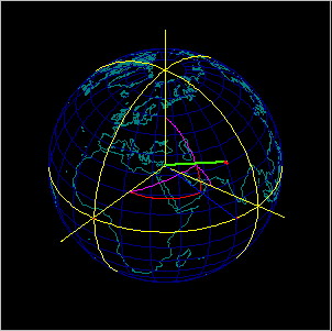
A point object is pictured on the surface of the Earth at North 30 degrees latitude and East 75 degrees longitude. This point is shown as the red head of a green vector. This vector is called the normal to the surface at N30 E75.
Three orthogonal reference axes are depicted in yellow together with the Equator, Prime Meridian and East 90 degree meridian.
The conventional latitude and longitude angles are depicted in bright red. (Surveyors always quote these angles relative to a specific reference ellipsoidal model of the Earth).
In contrast, three direction angles are depicted in bright magenta. These direction angles are the angles between the normal vector (green) and the reference axes. Direction cosines are simply the trigonometric cosines of the direction angles. (Like latitudes and longitudes, direction angles and their cosines are relative to a specific reference ellipsoid).
As the basis for calculating the geographic relationship between surface objects, latitude-longitude coordinates present several problems. First, one is forced to use conventional ellipsoidal trigonometry involving the transcendental functions such as sine, cosine, and arc tangent. This can adversely affect performance. Second, (and sometimes more important), the formulas are typically unstable at high latitudes or the dateline.
By contrast, once the direction cosines for an object are computed, subsequent calculations of spatial relationships DO NOT require use of transcendental functions. Instead, these calculations are carried out using a vector algebra requiring only floating add, subtract, multiply, divide and an occasional square root. Not only are these calculations much faster, they are numerically stable everywhere on the Earth's surface.
Another interesting property of direction cosines is that they readily may be compressed for storage efficiency without significant impact on their inherent computational efficiency.
"Concise Direction Cosines" (CDC) is a global coordinate format which retains only two out of the three (normalized) direction cosines. This is possible because the third cosine can always be recomputed from the other two since the sum of squares of all three always equals 1.
In this implementation, the two retained direction cosines are scaled to two 4-byte integers, the least significant two bits of which identify which of the three cosines has been dropped, and its sign. In this format, global geographic positions can be specified with a ground resolution of about one centimeter, anywhere, equivalent to that obtainable using similar encoding for latitude and longitude.
In keeping with the philosophy of the Hipparchus Library, CDC coordinates are specified in a form of a structure {u,v}, analogous to {x,y} or {lat,long}. An application may however consider them to be an array of two elements of integer type.
This form of geographic coordinate encoding is particularly useful in instances where computational efficiency is important. The advantage lies in the computational simplicity of the vector algebra required to determine relationships such as distance or direction, as compared to similar use of angular specifiers (lat/long) requiring calls to the trancendental functions such as sine, cosine, arc tangent, etc.
To demonstrate this fact, we offer for download a simple free demo program suite that compares the performance of a specific coordinate compression format with that of equivalently compressed lat/long angles.
bombay2la is a program demonstrating the convenience and speed of a concise direction cosine (CDC) form of global geographic coordinates. This code is offered as an illustration of a mathematical concept. It is supplied without warranty and presented without any restrictions on its use.
The scenario used to demonstrate the speed advantage of CDC's is straightforward. While it might lack realism, it is both simple to describe and results in code that does not cloud the central proposition: for spatial applications that are continental or global in scope, it is advantageous if the coordinates are recorded not as angular latitudes and longitudes, but in vector form, as direction cosines.
We assume a static database of point locations (airports of the world) and a transient, application-oriented, set of way-points on a flight path between two cities, Bombay and Los Angeles. The flight path is illustrated by the file bombay2la.png, which once unzipped may be viewed by any current net browser.
For each way-point on the flight path (representing, say, flight positions at successive five minute intervals during the flight), we want to find the nearest airport.
In order to eliminate the influence of external storage access, the application data is first loaded into memory arrays.
For each set, point coordinates are read and loaded in vector (CDC) form, then converted and loaded in an alternate compact (lat/long) form, both forms retaining a ground resolution of about one centimeter.
Two sets of nested loops are performed and timed:
In the first set of loops the proximities are determined using coordinates in CDC format and vector algebra, while in the second, proximities are determined using coordinates in lat/long form and conventional spherical trigonometry.
For each set of loops, a record is kept of the nearest airport along the flight line, and subsequently listed as a time-ordered set of airports.
Finally, the computation times for each approach are compared and reported.
Notes:
The great circle is computed using the cosine of the angle; this lacks the precision in the case of small distances; it is however simpler and faster than the sine computation based on Gauss-Delambre's equations.
The airport location file is used for illustrative purposes only without any suggestion that it is either correct or complete.
Download labombay.zip (295kb) now?